How will the Council’s proposed traffic filters affect Headington?
Oxfordshire County Council’s consultation on its proposals for 6 ANPR-enforced traffic filters in Oxford opened on 5 September and runs until 13 October 2022 (midnight). These traffic filters are one element of the Council’s Central Oxfordshire Travel Plan (“COTP”).
What are traffic filters?
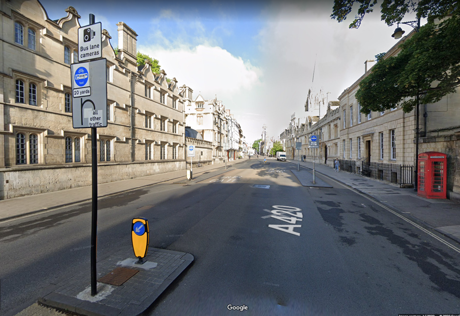
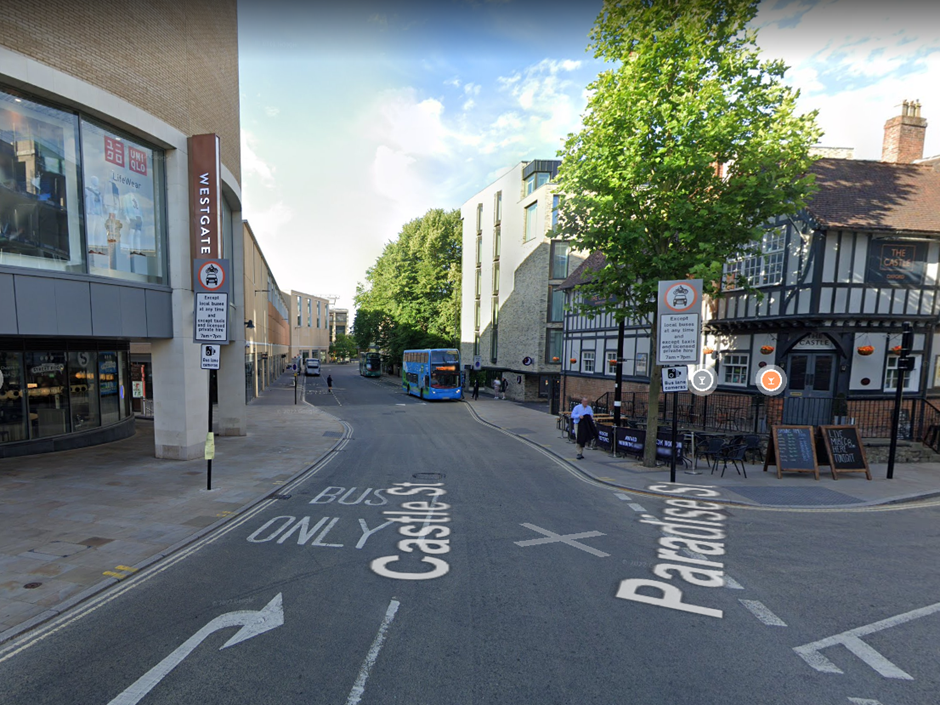
Traffic filters reduce traffic volumes by prohibiting most private motor traffic from passing through – only permitted and exempt vehicles will be allowed through. The traffic filters will consist of signs showing the traffic prohibition and Automatic Number Plate Recognition (ANPR) cameras to enforce compliance. They are likely to look something like these traffic filters that already exist in the city centre:
The traffic filters will let through buses, taxis, emergency and public service vehicles, blue badge holders, health and care workers and other categories of motor vehicle users. Bikes, e-bikes, wheelchairs, mobility scooters and other types of scooters are not affected by the filters and can pass through freely. See the Council’s Traffic Filters brochure for further detail about the exemptions and permits the Council is proposing. (We think these are too wide and permissive, but that’s for another article.)
What’s the Council’s plan?
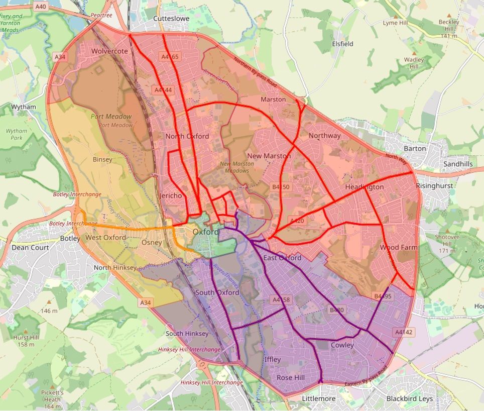
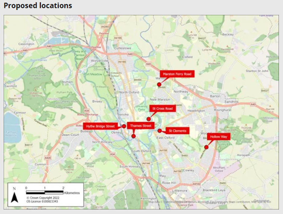
The Council is proposing 6 traffic filters in the positions shown on the map below:
The traffic filters form the basis of a traffic circulation plan which involves segmenting the city into different zones and preventing most private motor traffic from travelling between zones. Every road within every zone will still be accessible by motor vehicle, but journeys by private motor vehicle from one zone to another will involve going out to the ring road and coming back in via the appropriate exit for the destination zone. This means that each zone only gets ‘its own traffic’ – it doesn’t take the burden of traffic travelling through to other zones.
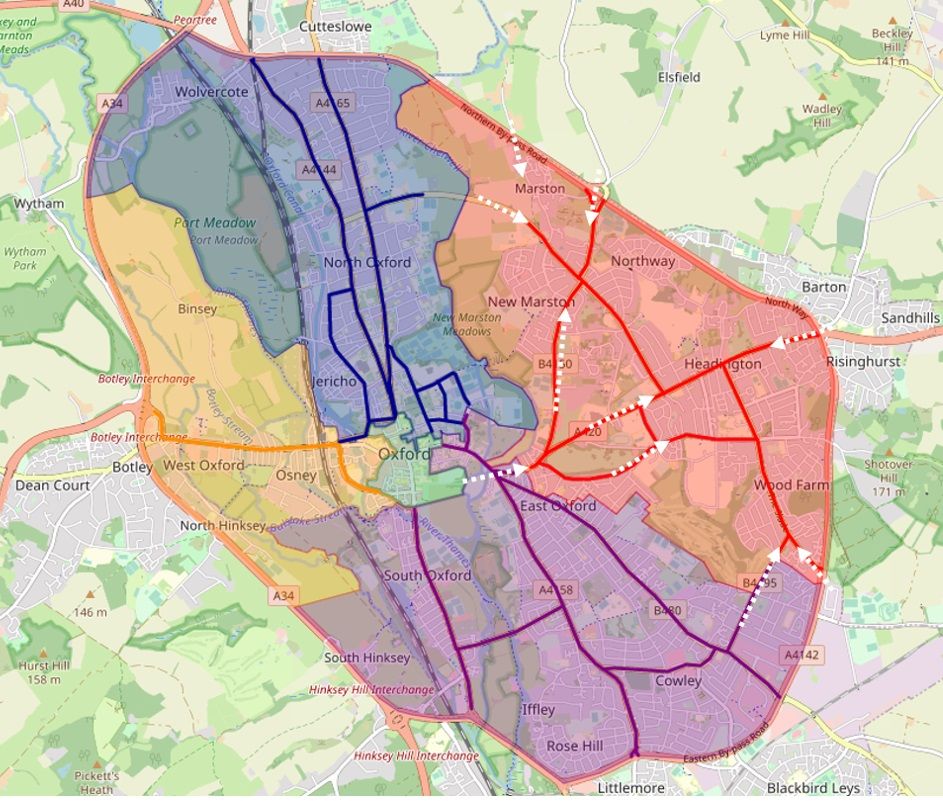
The current proposed positions for the traffic filters will create zones in Oxford that look something like this:
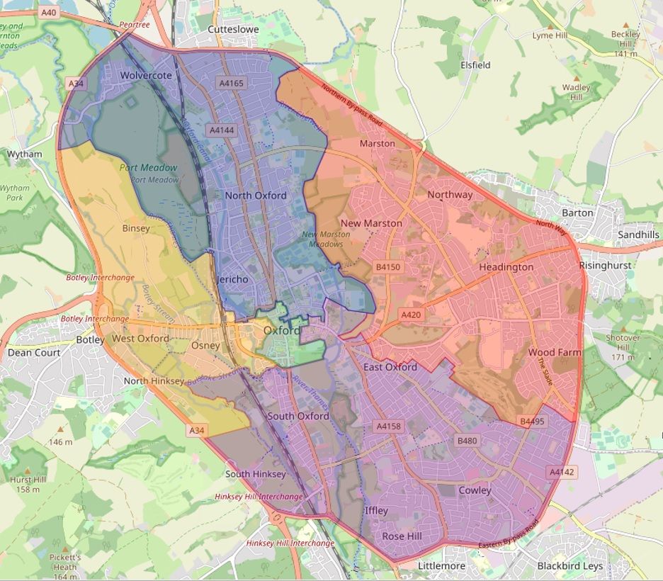
Each zone will be accessed from the Ring Road by its main roads, with the traffic filters preventing private motor vehicles travelling between zones, as shown below:

This will create 5 zones in Oxford:
- North (Jericho, Summertown, North Oxford, Wolvercote) – accessed via Woodstock Road and Banbury Road
- East (Old Marston, New Marston, Headington, Wood Farm, Lye Valley) – accessed via Marsh Lane, London Road, and Horspath Driftway
- South (East Oxford, Horspath, Cowley, Iffley, Rose Hill, Donnington, Grandpont, South Hinksey) – accessed via Cowley Road, Iffley Road and Abingdon Road
- West (Botley, North Hinksey, Binsey) – accessed via Botley Road
- Central (city centre) – created by already-existing traffic filters on Magdalen Street East, High Street, St Aldates, Speedwell Street, Castle Street, Queen Street and George Street.
The overall aim of these traffic filters is to create a traffic circulation scheme for Oxford that reduces motor traffic travelling through and across the city.
This reduction in traffic will:
- reduce congestion, road danger and pollution;
- enable improvements to existing bus service times and reliability and the creation of new bus routes; and
- make it safer and more pleasant for people to walk, wheel and cycle.
Necessary step for better buses
The scheme closely emulates a similar scheme undertaken in Ghent, Belgium, which has been hugely successful in reducing congestion, pollution and road danger and increasing cycling, walking and public transport use. This video explains how this was achieved in Ghent, and is well worth a watch to help understand the Council’s aims for the traffic filter scheme in Oxford.
The installation of these traffic filters is also a condition of obtaining funding from central government and the bus companies in Oxford to roll out a fully-electric bus fleet, thereby further reducing air and noise pollution. (See our article addressing ‘Approval of the National Bus Strategy – Draft Enhanced Partnership for Oxfordshire’ and Oxford Bus Company’s blog on ‘Why fixing congestion is just as important as technology in decarbonising our transport system’ for more information.)
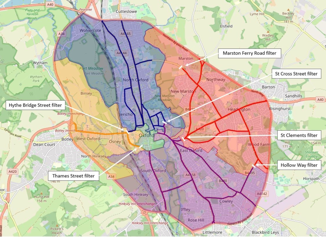
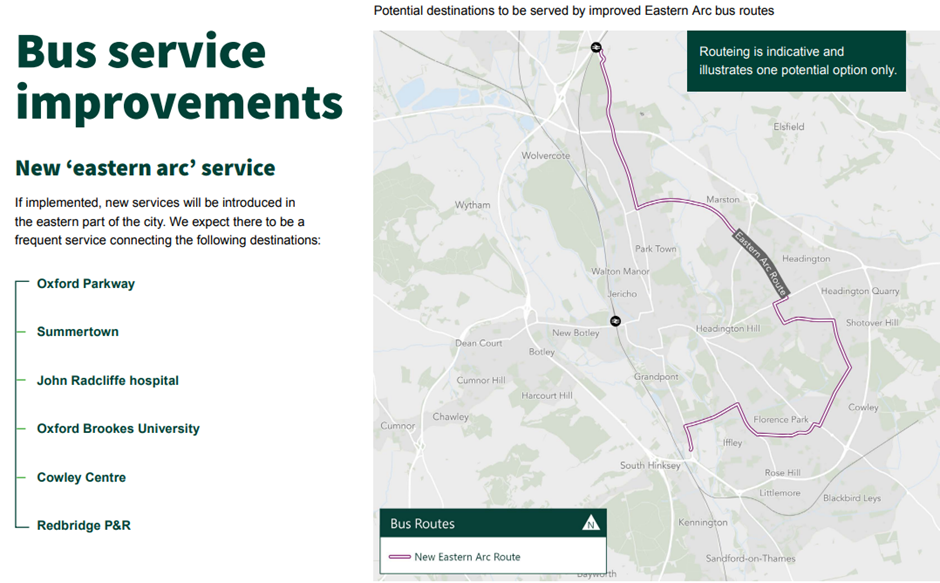
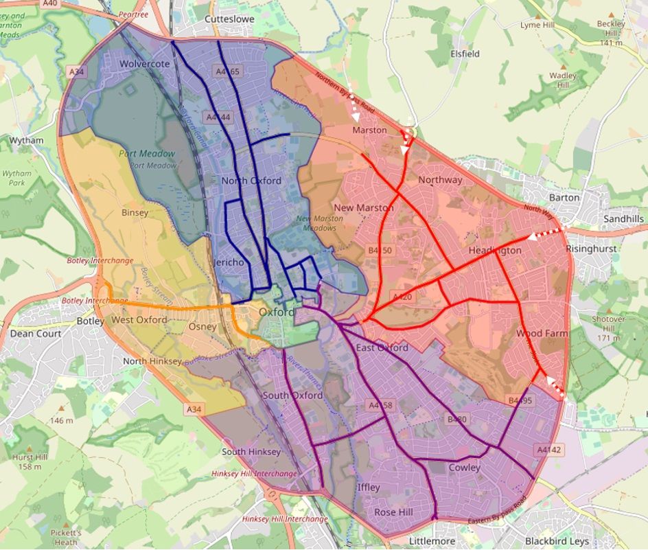
The Marston Ferry Road and Hollow Way traffic filters will also enable a new ‘Eastern Arc’ bus route to run, as shown below:
(See our article ‘Beware the ‘North-East high-traffic superblock’: why Headington needs a traffic filter on Marston Ferry Road’ for an explanation of how the traffic filters on the B4495, which includes Marston Ferry Road and Hollow Way, are required to improve existing bus services and launch new ones.)
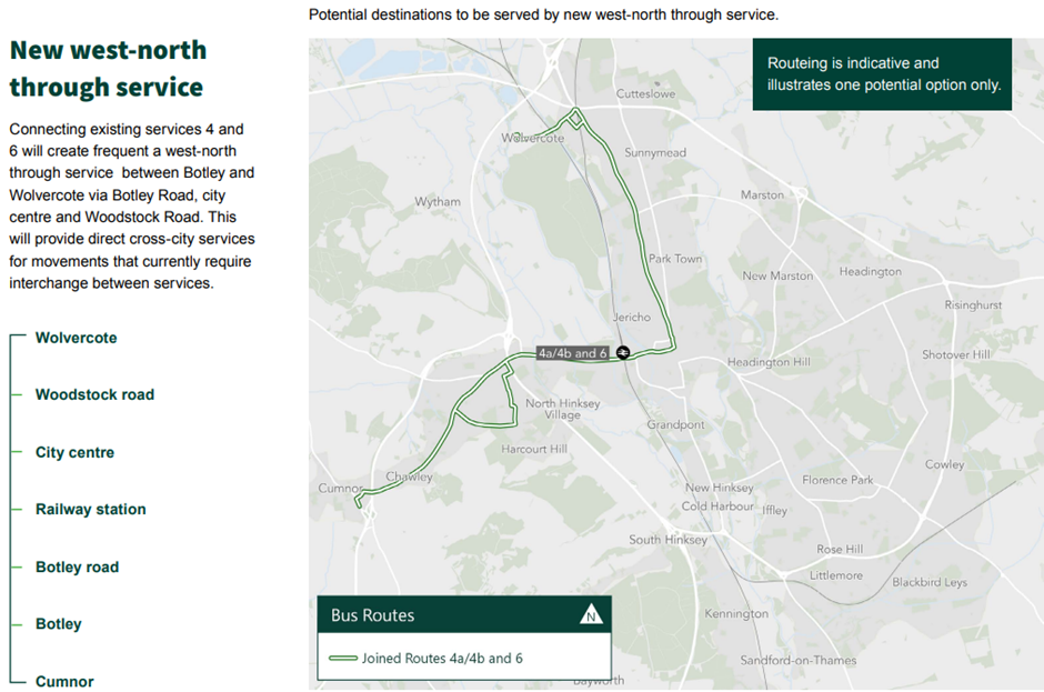
The city centre traffic filters will also enable new west-north bus routes, as shown below:
Will the traffic filters reduce traffic volumes in Headington?
The proposed traffic filters will remove some categories of traffic from Headington’s roads:
- The St Clement’s and St Cross Street filters will reduce private motor traffic driving through Headington to go to, or through, the city centre.
- The St Clement’s filter will reduce the amount of traffic driving through Headington to get to Cowley or Iffley Road (IF the East Oxford LTNs remain in place – see page 18 of the Council’s COTP Consultation Draft for detail of how the two schemes interact).
- The Marston Ferry Road filter will reduce the amount of traffic travelling through Headington to get to Summertown and beyond to Jericho, North Oxford, Cutteslowe, Kidlington, Eynsham and the City Centre via Banbury Road.
- The Hollow Way filter will reduce the amount of traffic driving through Headington to get to Horspath, Cowley, East Oxford, Blackbird Leys, Donnington and South Oxford.
However, the overall traffic-reducing effects of the COTP traffic filters is likely to be limited in Headington for a number of reasons explained below.
Much of Headington’s traffic is destination traffic
A large proportion of the traffic in Headington is ‘destination’ traffic to the 5 hospitals, Oxford Brookes University, Oxford University Old Road Campus, 7 state schools and 3 private schools.
(This will include Swan School, as it will be accessible from the South side of the traffic filter on Marston Ferry Road, meaning that anyone driving there will access it via the East zone.)
The filters will still allow all that traffic into Headington, but it will be channelled through a smaller number of access roads:
- Horspath Driftway – The Slade
- Green Road Roundabout – London Road
- Marsh Lane – Headley Way
- Elsfield Road – Cherwell Drive
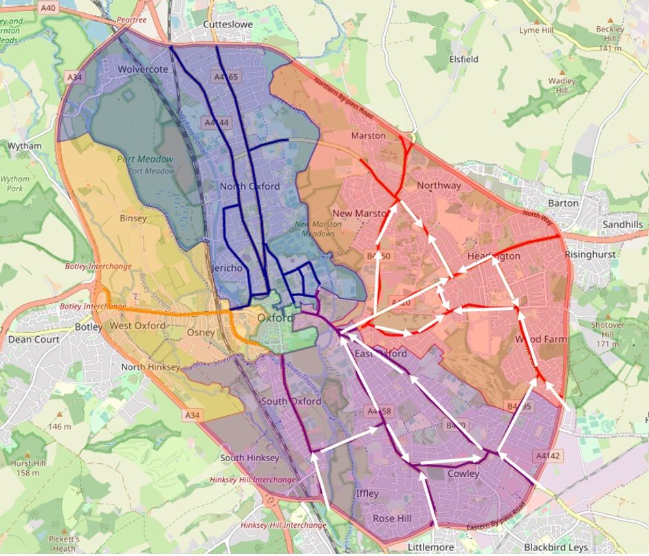
Without the filters, motor traffic destined for Headington currently arrives here from several access points as indicated with arrows in the map below:
With the traffic filters, motor traffic destined for Headington will arrive only from the Ring Road exits, as shown below:
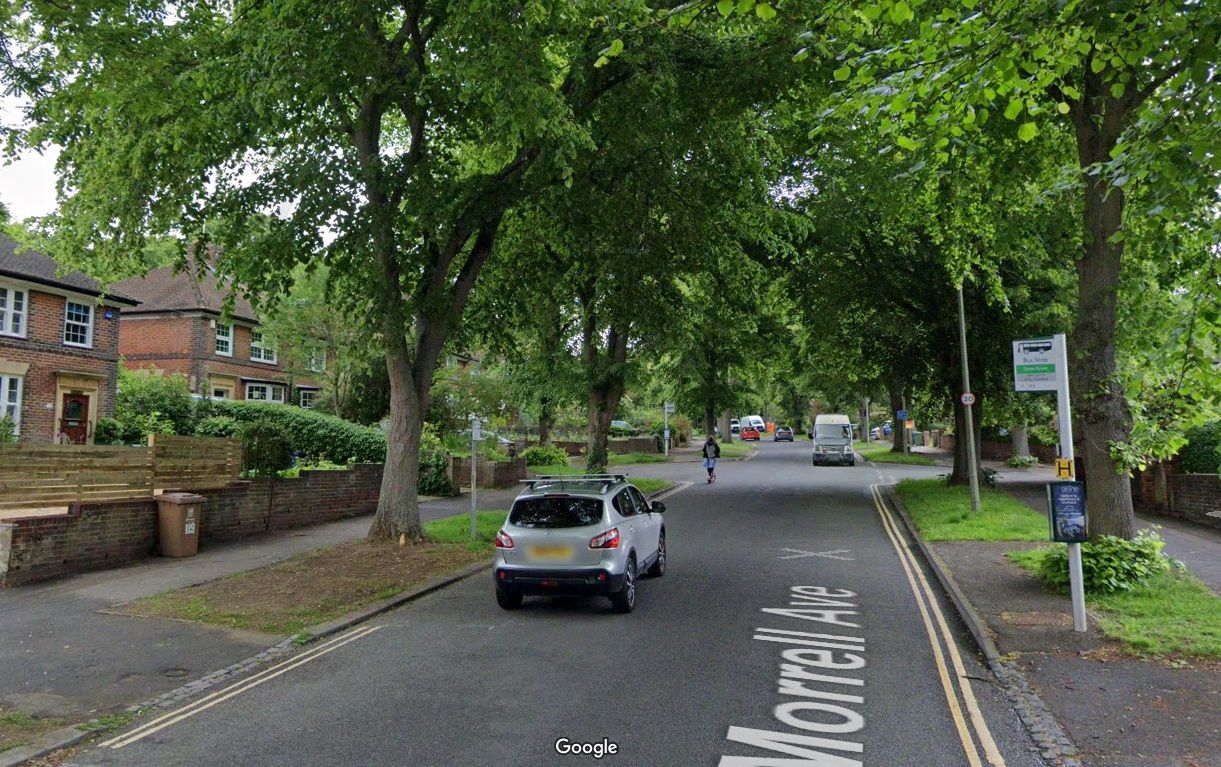
So, although the traffic filters are more likely to decrease than increase traffic volumes in Headington overall, we may see an unequal distribution of traffic between different roads, with a reduction of traffic volumes on the roads nearer the City Centre – Headington Road, Morrell Avenue and Marston Road, but an increase on the roads nearer the Ring Road – London Road, Headley Way, Gipsy Lane, Windmill Road, Old Road and The Slade.
Headington’s minor residential roads are at risk without low-traffic neighbourhoods
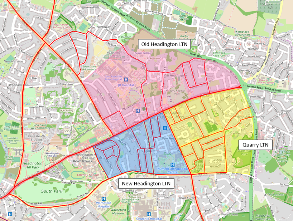
Without the Headington low-traffic neighbourhoods that were meant to be implemented in Spring this year (2022), and with potentially higher volumes of traffic being channelled into Headington via London Road, The Slade and Headley Way, Satnavs and drivers are likely to look to use Headington’s unfiltered and unprotected minor residential roads to avoid congestion and delays on the main roads and junctions, leading to increased volumes of through-traffic in Headington Quarry, Old Headington and New Headington. Coupled with the lack of any protected, adequate cycle lanes on Headington’s main roads, it may end up being even more dangerous and unpleasant to walk, wheel or cycle in Headington. (See our post ‘What’s happened to the Headington low-traffic neighbourhoods?’ for further information.)
The map below shows the areas in which the Council planned to trial low-traffic neighbourhoods:
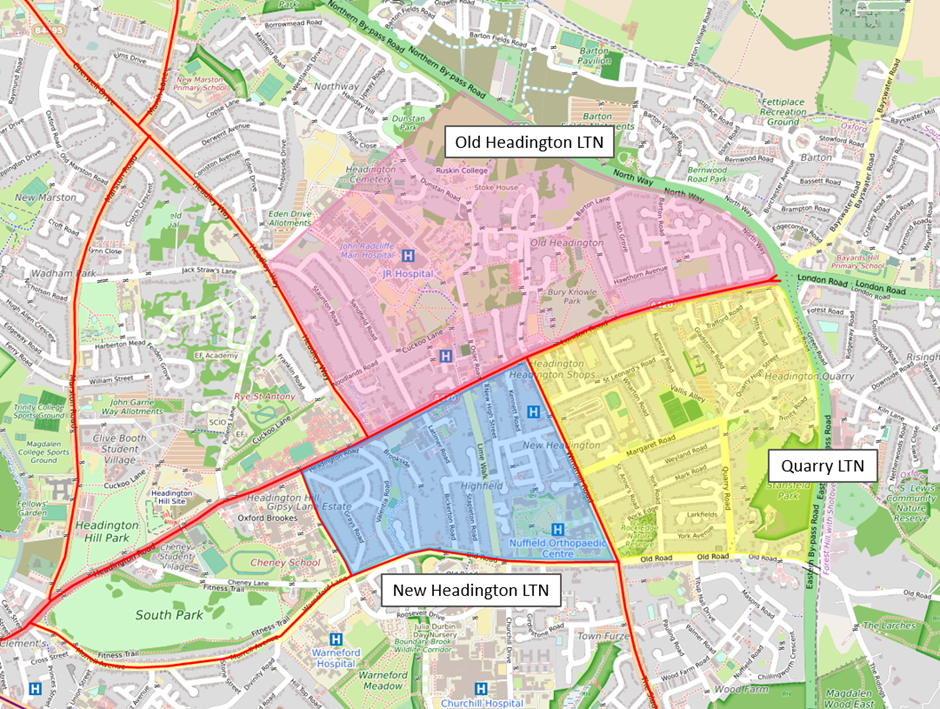
If these low-traffic neighbourhoods had been implemented, every single road in those areas would be protected from through-traffic.
Instead, without these low-traffic neighbourhoods, all the existing cut-through roads in these neighbourhoods will remain as high-traffic roads, and may even become even higher-traffic routes.
The map below shows the affected minor roads that serve as cut-throughs between the main roads:
Whatever happens to traffic volumes and flows in Headington as a result of the traffic filters, Headington still needs low-traffic neighbourhoods, and this need may increase with the changes to traffic in Headington that the traffic filters will bring.
Morrell Avenue will still be part of a high-traffic route
Two keys aim of the Central Oxfordshire Travel Plan (COTP) traffic filter scheme are to:
- prevent private motor traffic destined for Headington (particularly the hospitals) cutting through Cowley, Iffley, East Oxford and St Clement’s; and
- reduce pollution levels on St Clement’s Street, which is the most polluted road in Oxford.
The map below shows the current main road routes to Headington through Cowley, Iffley, East Oxford and St Clement’s, as indicated with arrows:
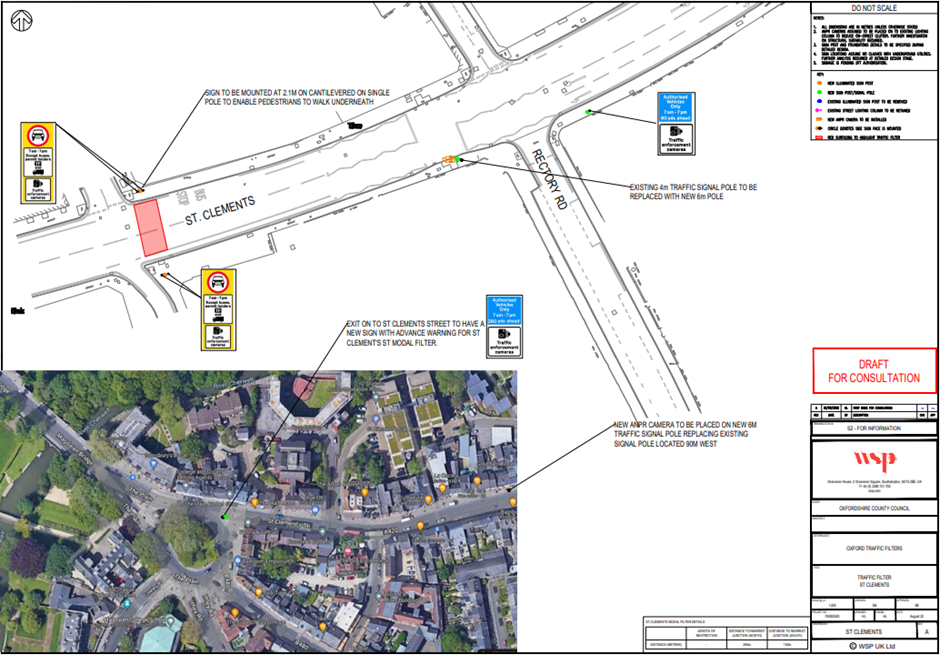
The Council’s traffic filter plans always included a filter on Hollow Way, but the Council has added a filter on St Clement’s to stop routes to and from Headington and Marston via St Clement’s Street, as shown below:
The traffic filters on Hollow Way and St Clement’s do achieve the aims described above, but because the St Clement’s filter is placed to the West of Morrell Avenue, it does not prevent an Old Road – Morrell Avenue – St Clement’s route to the hospitals, so there is a risk that traffic volumes will increase on Morrell Avenue, using the routes shown below:

This could be particularly problematic for Morrell Avenue, as this is a residential road that is not suitable for high traffic volumes.
Morrell Avenue has suffered from speeding through-traffic for many years and the road is difficult to cross due to the volume and speed of traffic and lack of pedestrian crossings.
There are a few options for addressing this problem, which are set out in our article ‘How can we make the Central Oxfordshire Travel Plan work for Morrell Avenue?’. These options all involve an additional traffic filter on Morrell Avenue or Warneford Lane and/or a re-positioning of the traffic filter on St Clement’s Street.
There’s some opposition to a traffic filter on Marston Ferry Road, but that filter is really important
The Marston Ferry Road traffic filter is (anecdotally, at least) the most strongly-opposed filter, but also the most important for improving the traffic situation in Headington. Headington needs the Marston Ferry Road filter, as explained in our post ‘Beware the ‘North-East high-traffic superblock’: why Headington needs a traffic filter on Marston Ferry Road’. Without that filter, Headington will continue to take the burden of private motor traffic headed to Summertown, Jericho, North Oxford, Cutteslowe, Kidlington, Eynsham and the City Centre via Banbury Road.
The Workplace Parking Levy may not remove much commuter traffic from Headington
The other COTP scheme, the Workplace Parking Levy, may not have much of a traffic-reducing affect in Headington as the large employers here that generate most of the commuter traffic – OUH NHS Trust, Oxford Brookes University and Oxford University – already operate quite stringent staff car parking permit policies under which only staff who live far away, have no reasonable public transport options or need to park on-site for disability-related reasons are allowed to apply for a permit and even then they have to pay for that permit.
As such, a charge to park at work may not be sufficient to persuade this category of workers to use an alternative to driving onto their employment site, unless they are provided with attractive alternative options such as free or significantly reduced P&R parking charges and bus fares, direct and regular shuttle buses from Thornhill P&R and/or safe, convenient cycling routes from Thornhill P&R to the hospital and university sites.
It also won’t prevent the category of workers who don’t qualify for staff parking permits and use free on-road parking spaces or rent Headington residents’ drives to park their cars from driving into Headington – only a reduction in on-road parking spaces and/or increased CPZ permit fees can tackle that source of Headington traffic.
Private schools are a particularly problematic generator of traffic in Headington
The private schools in Headington generate a large number of car trips here, bringing with them many associated problems – air pollution, congestion, reckless driving through our unprotected minor residential roads, dangerous, illegal and antisocial parking and engine idling. Many of these cars are SUVs, which, as the most polluting and lethal category of car, bring a disproportionate health and safety risk to Headington, particularly to children walking, wheeling or cycling to local schools. The traffic filters will not prevent any of these journeys or the problems they create.
Headington Liveable Streets’ view
Headington Liveable Streets supports the Council’s proposals for these traffic filters, including in particular the Marston Ferry Road filter, due to the benefits they will bring to Oxford as a whole in reducing congestion, pollution, road danger and improving bus services. This scheme needs to happen.
We have to face up to the fact that the only way to stop problem traffic in Oxford is to stop the problem traffic in Oxford, and that’s what the COTP traffic filter scheme aims to do.
However, as there’s little to protect or benefit Headington in the traffic filter scheme, we need additional measures in Headington to tackle the particular problems caused by our high levels of destination traffic as described above. This could include measures such as:
- Low-traffic neighbourhoods in Headington Quarry, Old Headington and New Headington to create safe cycling, wheeling and scooting routes between Headington’s main roads and hospital, university and school sites.
- Shuttle bus services from Thornhill P&R to the various hospital, university and school sites for staff, patients and visitors, with free/reduced P&R parking charges and reasonable bus fares.
- Greatly improved segregated and protected cycle routes on all Headington’s main roads, linking up Thornhill P&R and all the hospital, university and school sites to enable more people to cycle, wheel and scoot instead of using a car.
- Adding another filter and/or changing the position of the St Clement’s traffic filter to protect Morrell Avenue using one of the options described above. This would prevent Morrell Avenue from being used as a main road cut-through route and massively improve the safety and amenity of people who live and travel on Morrell Avenue.
- Consider additional traffic filters in Headington to further reduce traffic crossing Headington and moving through the main road junctions on Gipsy Lane and Windmill Road. These additional filters, along with a filter on St Clement’s Street (and one on Warneford Lane/Morrell Avenue) would have the effect of significantly reducing the amount of motor traffic passing through the Headley Way/London Road/Headington Road junction, the Headington Road/Gipsy Lane junction and the Old Road/Gipsy Lane/Roosevelt Drive junction, which would improve safety for cyclists and allow waiting times for pedestrians to be reduced.
- Private schools need to step up and take meaningful action to stop the negative impacts of the car journeys they generate, such as setting up shuttle buses from Thornhill P&R to the private school sites to avoid parents driving into Headington.
- Removal/reduction of on-road parking spaces and much-improved parking enforcement. The availability of free parking is known to be a huge generator of traffic, so removing the availability of legal parking spaces and properly enforcing against illegal parking on Headington’s roads is likely to result in a reduction in traffic volumes. The removal of parking on Warneford Lane is a great start; this now needs to happen on Cheney Lane to tackle the remaining Brookes student parking here and elsewhere. Reduction of resident CPZ parking and/or increasing CPZ residents’ parking permits would also help curtail the market in drive-renting in Headington, which is currently another generator of traffic.
We don’t favour the use the of congestion or pollution charging to regulate motor traffic access to Headington because we think this would have an iniquitous effect, imposing unfair barriers to the most vulnerable and disadvantaged – people who need to use a car to get to hospital due to illness or injury, whilst allowing the most privileged who inflict the most danger and pollution on our roads to continue using Headington’s roads unhindered. An outright ban on SUVs (i.e. private cars over a certain size and weight) entering Oxford would be more effective in removing the most polluting, dangerous and damaging vehicles from our roads.
So, to summarise our position: Oxford and Headington needs the traffic filters, but we also need so much more to help Headington cope with its destination traffic.
Related articles