Have you heard of Connecting Oxford?
Connecting Oxford is a comprehensive transport plan developed by Oxfordshire County Council and Oxford City Council setting out bold measures to reduce motor traffic, increase active travel and improve bus services across Oxfordshire. It was initially consulted on in 2019 and takes effect from 2023.
Everyone who lives or works in Headington needs to know about Connecting Oxford, as the plan has the potential to transform Headington for the better by massively reducing private motor traffic travelling to and through Headington and provides the wider transport picture in which Low Traffic Neighbourhoods will play a part.
It became clear from our visit to Headington Market in June that almost nobody knows about Connecting Oxford, so this article aims to introduce and summarise the plan. More detailed information can found on this dedicated public information website: Home – Connecting Oxford, including links to sign up to a mailing list and submit questions or comments and an FAQ page.
Connecting Oxford is described as “a bold plan from Oxfordshire County Council and Oxford City Council to tackle congestion, pollution and the poor transport connections into and across some parts of Oxford, particularly the city’s eastern arc”. (The Eastern Arc is the area outside the city centre that links North Oxford, Marston, Headington and Cowley.) The plan involves three key measures:
- Workplace Parking Levy
- Traffic filters (bus gates and low traffic neighbourhoods)
- Supporting schemes (buses and rapid transport, Park & Ride, walking and cycling routes)
Workplace Parking Levy (Workplace Parking Levy – Connecting Oxford)
The Workplace Parking Levy (“WPL”) is essentially a parking charge for staff at employment sites within the Eastern Arc, which will be paid either by the employer or passed onto the employees who wish to park. It will apply to all the Headington hospital sites, Oxford Brookes University Headington Campus, Oxford University Old Road Campus and probably schools.
This is likely to result in a significant reduction in the number of commuter journeys into Headington.
We know from our discussions with the big employer institutions that they are all fully supportive of the WPL scheme and have even proposed to the County Council that it should apply to the whole of Oxford, not just the Eastern Arc.
They just need the County Council to make this possible, e.g. by ensuring there is sufficient car and bike parking capacity and free or discounted parking fees at Thornhill P&R, and good bus services and safe cycling routes linking the various employment sites with Thornhill P&R.
Traffic filters (Oxford Traffic Filters – Reducing Traffic Congestion – Connecting Oxford)
Bus gates
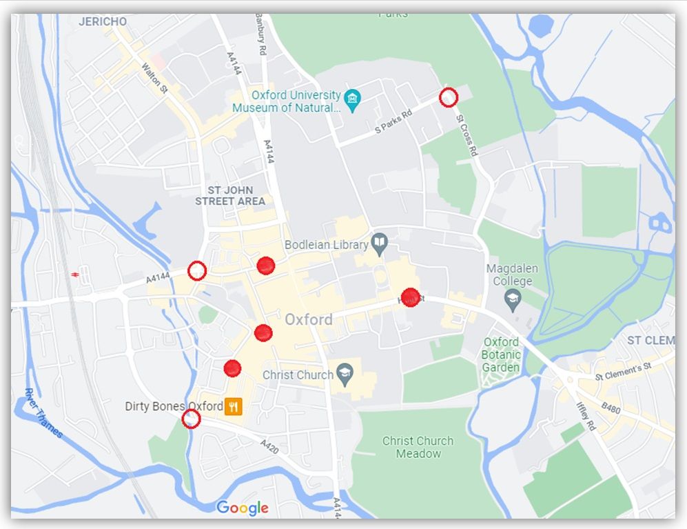
Oxford City Centre already operates a number of bus gates at High Street, George Street, Queen Street and Castle Street. In the two years following the bus gates being introduced on High Street, traffic reduced by around 60% on High Street, around 40% on Magdalen Bridge and around 20% in the city centre overall – so they are proven to be successful and have gained wide acceptance as being a good thing. The Connecting Oxford plan includes proposals for several bus gates in the following locations (the exact positions are not yet decided):
Central Oxford bus gates
- Hythe Bridge Street or Worcester Street, between Frideswide Square and Beaumont Street
- St Cross Road or South Parks Road, between Parks Road and Manor Road
- Thames Street or Oxpens Road
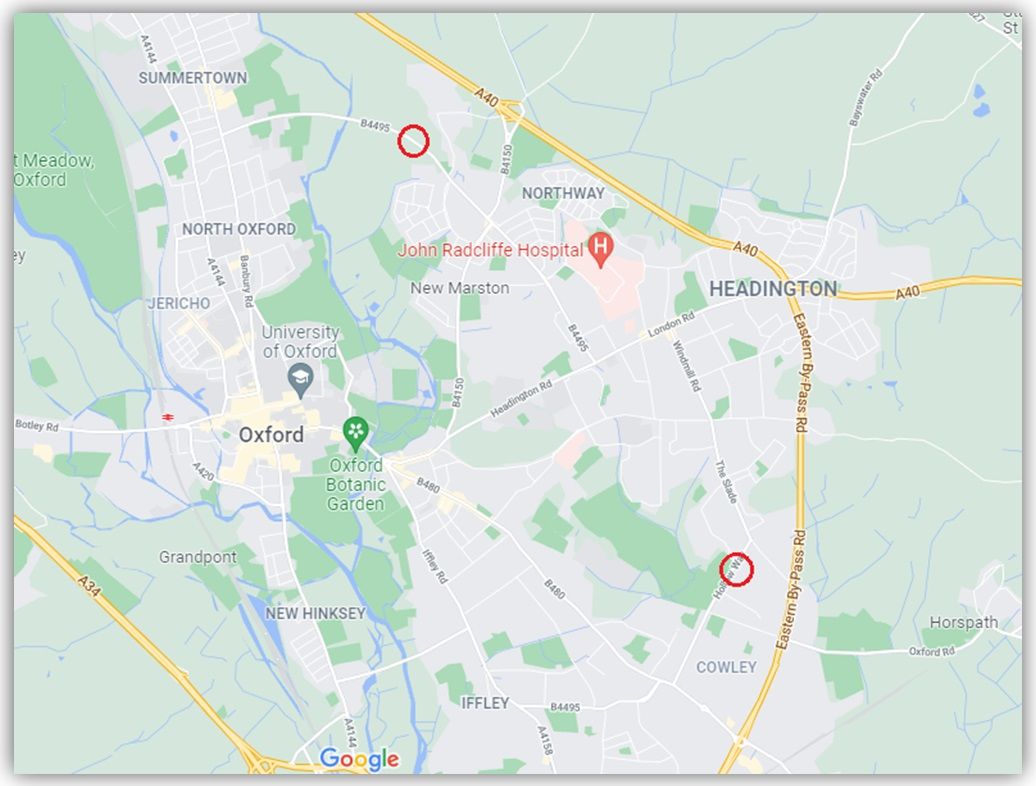
Eastern Arc bus gates
- Marston Ferry Road
- Hollow Way
The map below shows the approximate positions of existing city centre bus gates (solid red circles) and the proposed new bus gates (outline red circles):
And this map below shows the approximate positions of the proposed new Eastern Arc bus gates (outline red circles):
The proposed bus gates should reduce traffic in Headington in the following ways:
- The central Oxford bus gates will remove most of the private car traffic that currently travels along London Road – Headington Road or Old Road – Morrell Avenue to drive across the City Centre (e.g. to get to Summertown or Botley) or to access the Westgate and other city centre car parks (because the car parks will not be accessible from the Headington side of the central Oxford bus gates).
- The Marston Ferry Road bus gate will remove most of the private car traffic that currently travels along London Road – Headley Way – Marston Ferry Road (or shortcuts through Old Headington and Northway) to get to Summertown, making drivers travel round the Ring Road and access Summertown from the Banbury Road roundabout instead.
- The Hollow Way bus gate will remove most of the private car traffic that currently travels along London Road – Windmill Road – the Slade (or shortcuts through Headington Quarry/Rock Edge/Wood Farm) to get to Cowley, making drivers travel round the Ring Road and access Cowley from the Garsington Road roundabout instead.
Low Traffic Neighbourhoods
This element of the Connecting Oxford plan has been brought forward and implemented before the other proposed measures because the Government launched its Emergency Active Travel Fund in response to Covid-19 in May 2020, instructing local councils to implement schemes – including Low Traffic Neighbourhoods – to enable social distancing and safe walking and cycling, and invited local councils to bid for funding (see Traffic Management Act 2004: network management to support recovery from COVID-19). Oxfordshire County Council therefore took the opportunity to submit a bid for Low Traffic Neighbourhood schemes in Jericho, Cowley, East Oxford and Headington. See the County Council’s active travel page (Active travel – 2020-2022 | Oxfordshire County Council) and our previous articles on these schemes for more detail:
- Recent OCC decision on East Oxford LTNs reflects pledge to listen to people on future schemes
- Residents updated on the next phase of Low Traffic Neighbourhood trials in East Oxford
- ‘Transformational’: Low Traffic Neighbourhoods get the thumbs up in Cowley
Supporting schemes
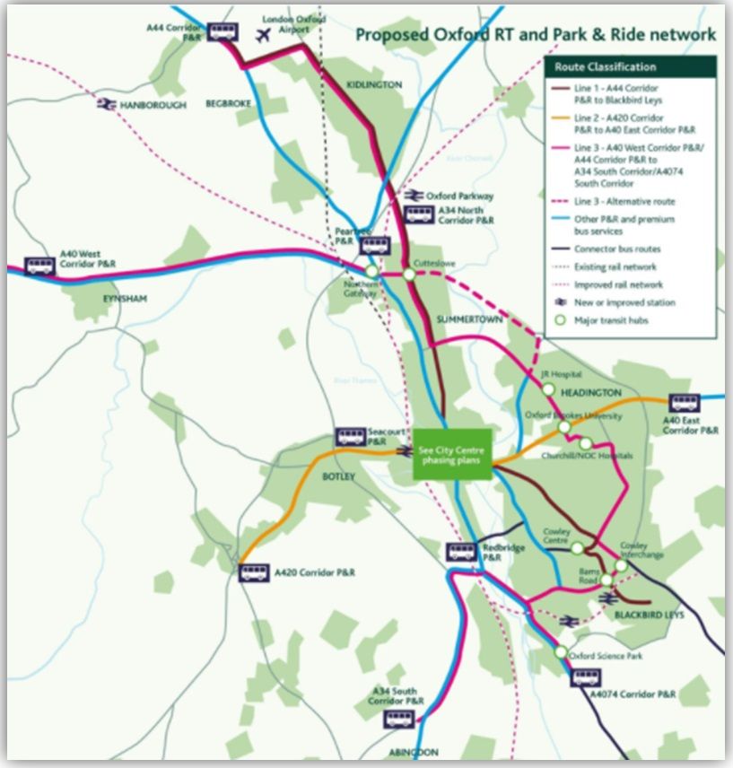
Bus and rapid transit (Buses/Rapid Transit – Connecting Oxford)
This involves the development of new and better bus routes and other improvements including giving buses road priority (which could use fully segregated bus lanes), higher quality zero emission buses, off-board ticket purchasing systems, faster methods of passenger boarding and fare collection, high quality passenger waiting facilities and real-time information systems. People who pay the Workplace Parking Levy will get significant discounts on their bus fares and cost of Park & Ride.
The map below (copied from the Connecting Oxford website) shows the proposed new routes, transit hubs and facilities:
Park & Ride
Five new ‘outer’ Park & Ride sites are proposed by 2050, to deal with current delays on approaches to the Oxford ring road during the morning period and morning traffic caused by people driving to Peartree, Water Eaton, Redbridge and Seacourt P&R sites contributing to traffic using the three A34 interchanges to the west of the city.
The idea is to reduce congestion on these approaches to the city by ‘intercepting’ car trips further away from the city, encouraging car users to park further from the city, to have a positive impact on the operation of the A34 and the other roads it intersects as vehicles using the new sites would no longer need to cross it.
Walking and cycling routes (Walking & Cycling Routes – Connecting Oxford)
This element of the Connecting Oxford plan aims to remove barriers to cycling and walking by providing a walking and cycling network that is continuous and high-quality and making it feel safe, enjoyable and convenient.
The Councils intend to use funds from central government to pay for immediate improvements to the cycling and walking infrastructure when the Workplace Parking Levy begins, then, once it is operational, use revenue generated by the Workplace Parking Levy to fund further improvements to cycling and walking routes within the city, also made possible through less traffic on the roads.
This map shows the proposed more developed cycling and walking network for Oxford in 2050: Oxfordshire Cycling and Walking Network for LCWIP, and the Connecting Oxford website says “This could mean cycle lanes that are wider and more clearly separated from the road and located in parts of Oxford which are less well served by cycle lanes at present”.
However, there are no detailed plans or drawings showing what this improved cycling and walking infrastructure will look like, and 2050 will seem a ridiculously long way off to anybody who currently has to use the mainly appalling cycling routes in Oxford, and as such this element of Connecting Oxford seems quite weak.
Consultation and timing (Consultation & Timing – Connecting Oxford)
The Councils are planning both informal engagement and further formal consultation on Connecting Oxford, although the website doesn’t provide a timeline for this yet. This throws doubt on whether this plan will be implemented within any meaningful timeframe, given that the problems it aims to address (congestion, pollution, poor public transport options and low quality and unsafe cycling and walking infrastructure) are bad now and only getting worse every day, and the Councils’ activities have obviously been delayed by the Covid pandemic.
In the meantime you can find links to register your views and sign up to receive email notifications on the Connecting Oxford – Oxfordshire County Council Consultation Portal.
If you are someone who supports LTNs in principle but is concerned about the impact of increased traffic on main roads, Connecting Oxford is the plan that will reduce traffic on main roads.
This presentation on ‘Oxford transport: The big picture’ by Danny Yee for Oxfordshire Liveable Streets provides an excellent summary of the transport challenges in Oxford and explains how Connecting Oxford and Low Traffic Neighbourhoods provide a joined-up solution to these challenges:
 admin
admin
Danny’s slides are available here.